注意: 此插件只是在测试环境论证过,如若在生产环境使用,请自行评估风险
参考:
https://mp.weixin.qq.com/s/uU-D6vdv6Nsi3xP1QRpRww
系统版本:
CentOS Linux release 7.3.1611 (Core)
准备工作: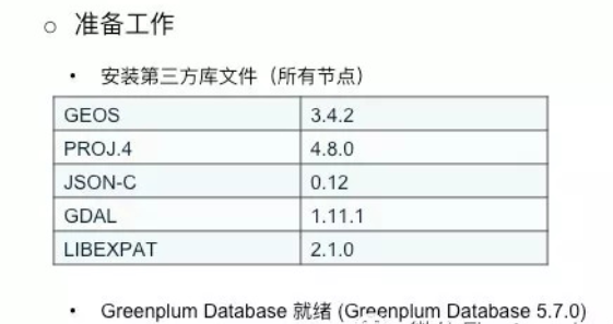
★进入gpadmin用户
>#su - gpadmin
★获取postgis包
>$ git clone https://github.com/greenplum-db/geospatial
★进入postgis
>$ cd geospatial/postgis/build/postgis-2.1.5/
★安装第三方库文件
install gdal 1.11.1:
wget http://download.osgeo.org/gdal/1.11.1/gdal-1.11.1.tar.gztar zxf gdal-1.11.1.tar.gzcd gdal-1.11.1./configure --prefix=$GPHOME (or other place you want, default is /usr/local)makemake install
install geos-3.4.2:
wget http://download.osgeo.org/geos/geos-3.4.2.tar.bz2tar jxvf geos-3.4.2.tar.bz2./configure --prefix=$GPHOMEmakemake install
install proj-4.8.0:
wget http://download.osgeo.org/proj/proj-4.8.0.tar.gztar zxvf proj-4.8.0.tar.gz./configure --prefix=$GPHOMEmakemake install
★编译
>$ ./configure --with-pgconfig=$GPHOME/bin/pg_config --with-raster --without-topology --prefix=$GPHOME --with-projdir=$GPHOME
PostGIS is now configured for x86_64-unknown-linux-gnu-------------- Compiler Info -------------C compiler: gcc -g -O2C++ compiler: g++ -g -O2SQL preprocessor: /bin/cpp -w -traditional-cpp -P-------------- Dependencies --------------GEOS config: /home/gpadmin/gpdb/bin/geos-configGEOS version: 3.4.2GDAL config: /home/gpadmin/gpdb/bin/gdal-configGDAL version: 1.11.1PostgreSQL config: /home/gpadmin/gpdb/bin/pg_configPostgreSQL version: PostgreSQL 8.3.23PROJ4 version: 48Libxml2 config: /bin/xml2-configLibxml2 version: 2.9.1JSON-C support: yesPostGIS debug level: 0Perl: /bin/perl--------------- Extensions ---------------PostGIS Raster: enabledPostGIS Topology: disabledSFCGAL support: disabled-------- Documentation Generation --------xsltproc: /bin/xsltprocxsl style sheets:dblatex:convert:mathml2.dtd: http://www.w3.org/Math/DTD/mathml2/mathml2.dtd
★安装
>$ make USE_PGXS=1 clean all install或>$ make USE_PGXS=1 clean all>$ make USE_PGXS=1 install
★导入环境变量
>$ export GDAL_DATA=$GPHOME/share/gdal>$ export POSTGIS_ENABLE_OUTDB_RASTERS=0>$ export POSTGIS_GDAL_ENABLED_DRIVERS=DISABLE_ALL
★重启数据库
>$ gpstop -a>$ gpstart -a
★激活PostGIS
>$ psql -d mydatabase -f ${GPHOME}/share/postgresql/contrib/postgis-2.1/postgis.sql>$ psql -d mydatabase -f ${GPHOME}/share/postgresql/contrib/postgis-2.1/postgis_comments.sql>$ psql -d mydatabase -f ${GPHOME}/share/postgresql/contrib/postgis-2.1/rtpostgis.sql>$ psql -d mydatabase -f ${GPHOME}/share/postgresql/contrib/postgis-2.1/raster_comments.sql>$ psql -d mydatabase -f ${GPHOME}/share/postgresql/contrib/postgis-2.1/spatial_ref_sys.sql
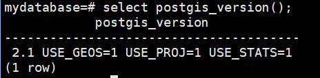
★PostGIS版本
mydatabase=# select postgis_version();
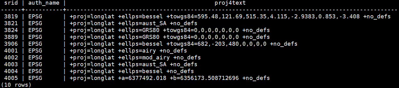
★PostGIS简单使用
参考: https://blog.csdn.net/gyfang/article/details/11661575
mydatabase=# SELECT srid,auth_name,proj4text FROM spatial_ref_sys LIMIT 10;
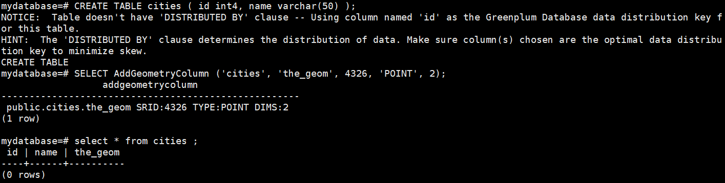
手工建立空间数据表格
mydatabase=# CREATE TABLE cities ( id int4, name varchar(50) );mydatabase=# SELECT AddGeometryColumn ('cities', 'the_geom', 4326, 'POINT', 2);mydatabase=# select * from cities ;
为添加记录,需要使用 SQL 命令。对于空间栏,使用 PostGIS 的 ST_GeomFromText 可以将文本转化为坐标与参考系号的记录:
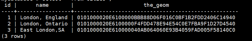
mydatabase=# INSERT INTO cities (id, the_geom, name) VALUES (1,ST_GeomFromText('POINT(-0.1257 51.508)',4326),'London, England');mydatabase=# INSERT INTO cities (id, the_geom, name) VALUES (2,ST_GeomFromText('POINT(-81.233 42.983)',4326),'London, Ontario');mydatabase=# INSERT INTO cities (id, the_geom, name) VALUES (3,ST_GeomFromText('POINT(27.91162491 -33.01529)',4326),'East London,SA');mydatabase=# select * from cities ;
空间查询:
这里的坐标是无法阅读的 16 进制格式。要以 WKT 文本显示,使用 ST_AsText(the_geom) 或 ST_AsEwkt(the_geom) 函数。也可以使用 ST_X(the_geom) 和 ST_Y(the_geom) 显示一个维度的坐标:
mydatabase=# SELECT p1.name,p2.name,ST_Distance_Sphere(p1.the_geom,p2.the_geom) FROM cities AS p1, cities AS p2 WHERE p1.id > p2.id;
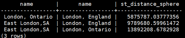
输出显示了距离数据。注意 ‘WHERE’ 部分防止了输出城市到自身的距离(0)或者两个城市不同排列的距离数据(London, England 到 London, Ontario 和 London, Ontario 到 London, England 的距离是一样的)。尝试取消 ‘WHERE’ 并查看结果。
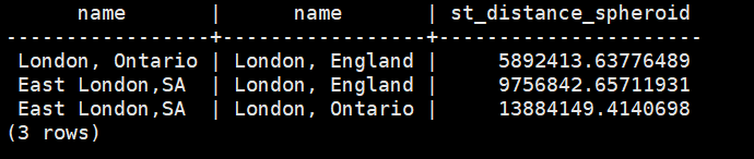
这里采取不同的椭球参数(椭球体名、半主轴长、扁率)计算:
mydatabase=# SELECT p1.name,p2.name,ST_Distance_Spheroid(p1.the_geom,p2.the_geom, 'SPHEROID["GRS_1980",6378137,298.257222]')FROM cities AS p1, cities AS p2 WHERE p1.id > p2.id;
本站文章,未经作者同意,请勿转载,如需转载,请邮件customer@csudata.com.
0 评论
添加一条新评论
用户登录

- 1PostgreSQL10~13版本以来的新特性史上最全总结 - 31 阅读
- 2关于PostgreSQL的分区表的历史及分区裁剪参数enable_partition_pruning与constraint_exclusion的区别 - 20 阅读
- 3查看PostgreSQL数据库进程占用内存的正确姿势 - 19 阅读
- 4通过修改NUM_BUFFER_PARTITIONS提升PostgreSQL数据库的性能的一次测试 - 18 阅读
- 5PostgreSQL数据库的高可用集群管理软件CLup - 18 阅读
- 6PostgreSQL14新特性:索引方面的增强 - 17 阅读
- 7Redis与RabbitMQ作为消息队列的比较 - 16 阅读
- 8PostgreSQL与MySQL 分析对比 - 16 阅读
- 9PostgreSQL官方手册CHM格式下载链接(新增了PG14英文版) - 16 阅读
- 10openGauss新手快速入门 - 16 阅读
- 1PostgreSQL新手指引 - 227 阅读
- 2PostgreSQL10~13版本以来的新特性史上最全总结 - 158 阅读
- 3查看PostgreSQL数据库进程占用内存的正确姿势 - 145 阅读
- 4PostgreSQL14新特性:索引方面的增强 - 143 阅读
- 5openGauss数据与PostgreSQL的差异对比 - 139 阅读
- 6PostgreSQL与MySQL 分析对比 - 135 阅读
- 7openGauss新手快速入门 - 133 阅读
- 8通过修改NUM_BUFFER_PARTITIONS提升PostgreSQL数据库的性能的一次测试 - 128 阅读
- 9行列转化的三种方法 - 124 阅读
- 10PostgreSQL官方手册CHM格式下载链接(新增了PG14英文版) - 119 阅读
- 1PostgreSQL新手指引 - 929 阅读
- 2PostgreSQL与MySQL 分析对比 - 688 阅读
- 3PostgreSQL10~13版本以来的新特性史上最全总结 - 626 阅读
- 4查看PostgreSQL数据库进程占用内存的正确姿势 - 588 阅读
- 5PostgreSQL14新特性:索引方面的增强 - 580 阅读
- 6openGauss新手快速入门 - 534 阅读
- 7PostgreSQL官方手册CHM格式下载链接(新增了PG14英文版) - 514 阅读
- 8ZQPool: 可以替代pgbouncer的连接池软件 - 511 阅读
- 9PostgreSQL数据库的高可用集群管理软件CLup - 504 阅读
- 10行列转化的三种方法 - 482 阅读